|
THE ROYAL
INCA TRAIL OF PERU
EL CAMINO REAL DEL INCA
By Miguel Chiri Valle
Around 500 years ago the Incas created the
biggest empire of all the American civilization. It took them about three generations to
build up an empire that started at the north in Colombia and ended in Argentina.
In order to keep this empire together the most important factor was their network of roads
that went from north to south, forming El Camino Real. This road went through the Andes and
part of the coast, having side roads that connected with the main artery.
These roads were known by the Inca culture, since they represented the government and its
presence in the Tawantinsuyo (Inca Empire). The first Europeans who traveled in the Andes
saw that the roads were bigger and better made than the ones used in Europe, even superior
to the Roman roads. Some experts have said that this network of roads created by the Inca
Empire is the major archaeological monument in the Americas.
The Incas organized the construction of the roads through a system called LA MITA, an
obligation of the population to work a couple of weeks a year in state constructions. The
maintenance of the roads was continuous to keep them in good condition and prevent erosion
and damage from frequent use.
Along the roads they built warehouses called Tambos (Tampu). In these buildings were stored
food, clothing, and weapons. The overseer of the Tambo would supply goods and lodging to
the imperial officials who were traveling throughout the empire.
In some parts of the Andes the Incas found a network of roads built by pre-Inca
civilizations. These roads were included in their system, many not needing additional
construction.
In other areas they had to build their own routes, because there were no formal roads
or because the local routes did not go where the people wanted to go. The construction of
the road varied according to the composition of the ground. the topography, the utilization
of the land, the amount of traffic, and the effects of rain and snow.
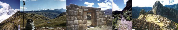
In some parts the royal road was between three and eight meters wide, being more narrow in
steep places. There were places with stairs, stone-paved stretches, and a variety of
retaining walls that were part of the roads. In the deserts of Perú the roads were marked
by sticks and by rock piles.
The hanging bridges in the road were also famous, made of plant material forming strong
ropes across great canyons like the ones found crossing the Pampas and the Apurimac river.
Some other bridges were made of rock. These usually crossed small streams.
This network of roads was used primarily to keep open the communication within
the Tawantinsuyo. The imperial army used the roads continuously as did the Imperial
officials and the Chasquis, who were the messengers of the empire. These runners, the
Chasquis, were able to take messages from Cusco to Quito in a week or less. To control
the flow of the people using these roads, there were sentry posts in strategic places,
mostly near bridges.
The principal roads were mainly in the Andes in Peru, running from Cusco to Quito; on the
coast they ran from Nasca to Tumbes. Also the roads continued throughout Colombia,
Bolivia, Argentina and Chile.
FOR FURTHER INFORMATION OR
GUIDING SERVICES, CONTACT US
Thank you for visiting my Page!!
peru-travel@hotmail.com
© COPYRIGHT 2008
ALL RIGHTS RESERVED
|